Year 6 were studying Ordinance Survey maps of Sunderland and Durham. Our objective was to understand how maps use scale. We had to use our mathematical skills to convert the distance on the map to the distance in real life using the scale.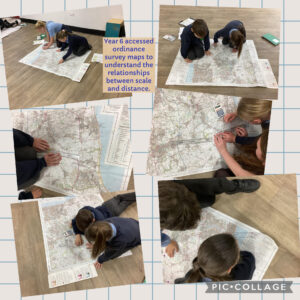
- School
- Welcome to St Oswald’s CE VA Primary School
- Staffing Information and Contact Details 2025-2026
- Vision, Ethos and Values
- Safeguarding
- Child Protection Policy
- Child on Child Abuse Policy
- Designated people to collect
- Designated Safeguarding Team
- Prevent Strategy
- Operation Encompass
- Internet Safety
- Playstation 5 parental guidance
- Nintendo Switch Advice
- TikTok
- Tik Tok Advice for Parents
- Parenting in a Digital World
- E-safety and Acceptable Use Policy
- Keeping your child safe on YouTube
- Keeping your child safe on XBox with a Family Membership
- Snapmaps
- Teens on tinder
- Ask.fm
- Start talking PANTS!
- Snapchat Safety
- Internet Matters online safety guide
- Don’t pay the price for your child’s online fun
- Computer Safety for 5-7 years
- Computer safety 8-10 years
- Cyberbullying
- Protecting your children from abuse online
- Whats App
- Online Safety Guide to Sexting
- Netflix
- Wellbeing
- School Performance
- Information
- Paper Copies
- School Opening Times
- Term Dates
- Diary Dates 2025-2026
- Calendar
- Community
- Attendance
- GDPR
- Complaints Procedure
- Equality Information, Objectives & Compliance
- Policies
- Admissions Policy 2025
- Admissions Policy 2026
- Teaching and Learning Policy
- Anti-Bullying Policy
- Attendance Policy
- Behaviour Management Policy
- Charging & Remissions Policy
- Collective Worship Policy
- Homework Policy
- Image Use Policy
- Religious Education Policy
- RSE Policy
- Sun Protection Policy
- Uniform Policy Document
- Packed Lunch Policy
- SEND
- Sports Premium
- Curriculum
- Curriculum Rationale
- Curriculum Responsibilities
- Curriculum Long Term Plans
- Medium Term Plans
- English
- Maths
- Science
- RE
- PE
- History
- Geography
- Music
- Languages
- Art & Design
- Design Technology
- RHSE
- SMSC
- Computing
- Collective Worship
- Our Ozzie 80
- Parents
- Parental Workshops
- Primary Age Mental Health Advice
- Facebook Guidance Notice
- National Curriculum Tests & Reception Baseline Assessment
- Complaints Procedure
- Mental Health Advice
- Uniform Orders & Provision of Second-hand Uniform
- Parent/Carer/Visitor Code of Conduct
- Admissions Arrangements
- ‘Wrap around Care’
- County Lines Parental Information
- Our News
- Governors
- Home Learning
- New Starters